


Weather - Routing - Navigation
Weather - Routing - Navigation ၏ ရွင္းလင္းခ်က္
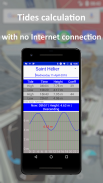
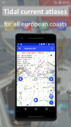
SailGrib WR သည်ရာသီဥတု၊ ဒီရေ၊ ဒီရေစီးကြောင်း၊ လမ်းကြောင်း၊ NMEA၊ AIS၊ ဇယားများ၊ ပြီးပြည့်စုံပြီးအသုံးပြုရလွယ်ကူသည်။
သင်ဟာအပန်းဖြေလှေ၊ ကမ်းခြေသို့မဟုတ်ကမ်းလွန်အပြေးသမားဖြစ်လျှင် SailGrib WR သည်သင်၏လိုအပ်ချက်အားလုံးကိုဖုံးလွှမ်းသည်။
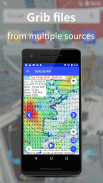
- မထွက်ခွာမီမိုးလေဝသနှင့်လက်ရှိ ၀ ယ်ယူမှု (ချုပ်ထားသောဖိုင်များ၊ isobaric မြေပုံများ၊ ဂြိုဟ်တုပုံများ)
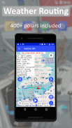
- လမ်းကြောင်း: မင်းရဲ့ဆန္ဒအတိုင်းသင့်လမ်းကြောင်းကိုပိုကောင်းအောင်လုပ်ပါ။ ကျွန်ုပ်တို့၏ဝင်ရိုးစွန်း ၄၀၀ ကျော်ကို သုံး၍ သို့မဟုတ်သင်၏ကိုယ်ပိုင်တည်ဆောက်ပါ။
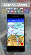
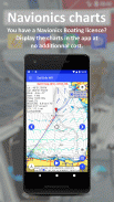
- ဇယားများ: GeoGarage raster charts (SHOM, UKHO, NOAA .... ) သို့စာရင်းသွင်းပါသို့မဟုတ် Navionics Boating app မှသင်၏ဇယားများကိုသုံးပါ။
Iridium Go နှင့်ကမ်းလွန်ရာသီဥတု အပြောင်းအရွှေ့အရွယ်အစားကိုလျှော့ချရန်အစွန်းရောက် optimization နှင့်
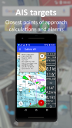
နှိုးစက်များနှင့် AIS
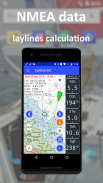
- သင်၏ NMEA ဒေတာနှင့်စွမ်းဆောင်ရည်ခြေရာခံပါ
- နှိုးစက်
- Navygatio (Beta) နှင့်သင်၏ရွက်လွှင့်ခရီးများကိုမြင်ယောင်ပါ၊ မျှဝေပါနှင့်ခွဲခြမ်းစိတ်ဖြာပါ။
ဤအရာအားလုံးသည်ရိုးရာဖြေရှင်းနည်းများနှင့်နှိုင်းယှဉ်လျှင်အလွန်နိမ့်သောကုန်ကျစရိတ်ဖြစ်သည်။
SailGrib WR သည် ၂၀၂၁ ခုနှစ်ဧပြီလတွင်ကမ္ဘာ့ ဦး ဆောင်သောကမ္ဘာလုံးဆိုင်ရာလှေအငှားပလက်ဖောင်းဖြစ်သော Zizoo (https://www.zizoo.com/en/m/best-sailing-apps-for) မှ ၂၀၂၁ ခုနှစ်၊ ရွက်လှေ (အပျော်စီး)
SailGrib WR ကိုVendée Globe (Armel Tripon), Figaro 3, Mini 650, IRC ...
မှတ်ချက်။ အကယ်၍ သင်သည် Virtual Regatta Offshore ကိုကစားလျှင်သင်၏လမ်းကြောင်းကိုလုပ်ဆောင်ရန်နှင့်သင်၏အစီအစဉ်များကို VR သို့တိုက်ရိုက်ပို့ရန် SailGrib4VR ကိုသုံးပါ။ ၎င်းသည်အလွန်ထိရောက်သည်။
PREMIUM OPTION
Premium Option ကို ၀ ယ်ယူခြင်းကို ၁ လ၊ ၁၂ လ (အလိုအလျောက်ပြန်လည်သက်တမ်းတိုးနိုင်သော) သို့မဟုတ်တစ်သက်တာအတွက်တစ်ကြိမ်ငွေပေးချေမှုဖြင့် ၀ ယ်နိုင်သည်။
- ပရီမီယံကြေးပေးသွင်းခြင်းသည် app ၏အင်္ဂါရပ်အားလုံးကိုသုံးခွင့်ပေးသည်။
- ၀ ယ်ယူမှုအတည်ပြုပြီးပါကငွေပေးချေမှုကို Google Play အကောင့်မှငွေထုတ်ပေးလိမ့်မည်။
- စာရင်းပေးသွင်းမှုသည်အလိုအလျောက်သက်တမ်းတိုးသည်။
- သင်၏စာရင်းပေးသွင်းမှုကိုပယ်ဖျက်ရန် Google Play Store အက်ပ်သို့သွားပါ၊ သို့မဟုတ်ဤ link သို့သွားပါ https://support.google.com/googleplay/answer/7018481?co=GENIE.Platform%3DDesktop&hl=en
သင်၏စာရင်းပေးသွင်းမှုကိုသင်ပယ်ဖျက်ပါကအခပေး ၀ န်ဆောင်မှုပြီးဆုံးသည်အထိဆက်လက်ရှိနေလိမ့်မည်
အွန်လိုင်းအကူအညီ-https://www.sailgrib.com/sailgrib_wr-support/
FB အသုံးပြုသူများအဖွဲ့ - https://www.facebook.com/groups/sailgriben
Weather - Routing - Navigation - ဗားရွင္း 8.1
(07-09-2024)Weather - Routing - Navigation - APK သတင္းအခ်က္အလက္
APK ဗားရွင္း: 8.1package: com.sailgrib_wrWeather - Routing - Navigation ၏ ေနာက္ဆုံးဗားရွင္း
အျခား ဗားရွင္းမ်ား


က႑တူအက္ပ္မ်ား

သင္ႏွစ္သက္ႏိုင္သည္မ်ားမွာ...


